Cape Province, also called Cape of Good Hope, Afrikaans Kaapprovinsie or Kaap die Goeie Hoop, former province of South Africa, occupying the southern extremity of the African continent. The Cape of Good Hope is at the southern tip of the Cape Peninsula, about 2.3 kilometers (1.4 mi) west and a little south of Cape Point on the south-east corner.
Cape Town is about 50 kilometers to the north of the Cape, in Table Bay at the north end of the peninsula. The peninsula forms the western boundary of False Bay.
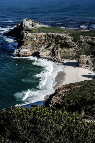
Geologically, the rocks found at the two capes, and indeed over much of the peninsula, are part of the Table Mountain Group, and are formed of the same type of sandstones as Table Mountain itself.
It was first sighted by the Portuguese navigator Bartolomeu Dias in 1488 on his return voyage to Portugal after ascertaining the southern limits of the African continent.
One historical account says that Dias named it Cape of Storms and that John II of Portugal renamed it Cape of Good Hope (because its discovery was a good omen that India could be reached by sea from Europe); other sources attribute its present name to Dias himself.
The cape’s early Dutch-speaking settlers gradually evolved a distinct variant of that language known as Afrikaans, and they themselves became known as Afrikaners, or Boers. By 1700 Afrikaner grain, wine, and fruit farms were scattered along the eastern foot of Table Mountain (which overlooks Table Bay) as well as along the western foot of the small mountain ranges 30–40 miles (50–65 km) to the east.
The Khoekhoe offered no resistance to this encroachment and withdrew before the colonists or accepted service with them as shepherds, guides, and interpreters; in the smallpox epidemic of 1713 thousands of them died.
The surviving Khoekhoe fled, and by 1730 no remnants remained within 250 miles (400 km) of Table Bay. In the union, the Cape Province was soon outstripped economically by the heavily industrialized Transvaal, which also surpassed it in population.
Nor was the Cape Province’s comparatively liberal voting franchise copied by the other provinces, which continued to deny any voting rights whatsoever to nonwhite South Africans. Indeed, the Cape withdrew voting rights from Africans in 1936 and from Coloureds in 1956.
Panorama of the Cape of Good Hope South Africa
In 1500 Dias accompanied Pedro Cabral on the voyage that resulted in the discovery of Brazil. The expedition then turned back towards the south coast of Africa and on 29 May it fell victim to a cyclone.
Bartolomeu Dias drowned at sea along with the crew. In 1960, a statue of Dias was unveiled in Cape Town. The whole of the southernmost portion of the Cape Peninsula is the wild, rugged, scenic and generally unspoiled Table Mountain National Park.
The park runs approximately north-south along the range of mountains that make up the mountainous spine of the Cape Peninsula, from Signal Hill in the north, through Lion’s Head, Table Mountain, Constantiaberg, Silvermine Nature Reserve, the mountains of the southern Peninsula, and terminates at Cape Point.
The park is not a single contiguous area; the undeveloped mountainous areas which make up most of the park are separated by developed urban areas on shallower terrain. Thus the park is divided into three separate sections.